One of the joys of being retired is usually freedom of time and as the temperature began to approach the 100’s in Billings I decided to leave town on the spur of the moment and spend three weeks exploring the Rocky Mountains of northwestern Montana (where hopefully it will be cooler – turned out NOT!) The plan is to head northwest from Billings to Glacier National Park, cross over into the Flathead Valley, explore the forests of the northwest corner of Montana, then turn east and tour central Montana before returning south to Billings. Augie the doggie and I packed up and hit the road. Come along!
Billings, MT to St. Mary, MT (Hwy 3 to Hwy 12 west to White Sulphur Springs, MT; north on Hwy 87 to Hwy 200 to Great Falls, MT; north on I-15 to Shelby, MT, west on Hwy 2 to Browning, MT, north on Hwy 89 to St. Mary, MT}.
 The Rocky Mountains in Montana are somewhat shaped like a horizontal “T”, generally running north/south through the western two-fifths of Montana with horizontal spur jutting east for over a hundred miles. This horizontal range of mountains divides the plains of central Montana into the northern plains, stretching across the Missouri River towards Canada, and the south, reaching across the plains to Billings and Wyoming beyond. South of the mountains the Musselshell River runs east before finally turning north to join the Missouri; north of the mountains the much larger Missouri River runs east into North Dakota before eventually turning southeast and merging with the Mississippi in Missouri. We start by following up the Musselshell River Valley west to White Sulphur Springs, then heading north to cross the mountains via Hwy 87, finally emerging onto the northern prarie and Hwy 200 at Belt, MT, before heading northeast to Great Falls and I-15 to Shelby. The day is warm and crossing the mountains offers a bit cooler temperature but, of course, we inevitably run into the scourge of driving during the summer in Montana, road construction. Due to the winter weather conditions, road construction throughout the state is crammed into the May-October time span and it is everywhere. Highway 87 is not a main highway and so the strategy is to shut one lane of the narrow two-lane highway completely and use pilot cars to lead caravans, alternating each way. Augie and I got to sit for 35 minutes in the heat, enjoying the view… Remember that a motorhome is essentially a large aluminum can on wheels and even in one as well insulated as the Lunch Box, the heat builds quickly!
After we emerge out of the mountains the vast plains of the north spread before us, unfolding in an undulating landscape that extends all the way to the North Pole. This is a relatively dry area, relying upon winter snows for most of the moisture for agriculture. Grains grow well up here, and ribbons of green and brown flow across the land. In order to not exhaust the soil, alternating fields are planted every other growing season, letting the land sit fallow and restore itself before the next planting. In every direction the view is essentially the same as it has been for decades with the addition of that new American icon, the wind turbine, reaching into the blue skies.

At Shelby, near the Canadian border, we turn and head directly west on Hwy 2. At first the landscape is unchanged, but after cresting a small hill the “Ramparts of God” are suddenly visible in the distance as far as the eye can see, both north and south.

The Front Range rises up from the gradually rising plains with minimal foothills. This is the land of the Blackfeet Indians, a proud and powerful people who dominated the northern plains prior to the coming of the pioneers. For some time we have been in the Blackfeet Indian Reservation, a vast territory of over 3,000 square miles (larger than the state of Delaware) that spreads along the eastern plains at the foot of the Rocky Mountains. The culture of the Blackfeet was decimated near the turn of 20th century with children taken away from parents and raised in boarding schools, forbidden to practice the native religion and other practices. The forced immersion into the “American” culture, lead by Catholic missionaries, ended decades ago but the damage to the spirit of the tribe has yet to be completely healed. The defining man-made structure of modern northern Montana is the railroad. In the early 1890’s the Great Northern Railroad, led by James J. Hill (“The Empire Builder”}, conquered the Rocky Mountains at Marias Pass just west of here along the southern edge of what is now Glacier National Park. The railway connected Seattle, Washington, with the east United States and remains today as the prime commercial rail link along the northern United States. Highway 2 parallels the railroad for most of the way, and huge trains collect as they wait to take their turn at crossing the pass. To the left is the view south from the highway, to the right is the train lined up on the north. I took this picture through the windshield and that’s the remnants of some Montana “wildlife” blurring the picture!


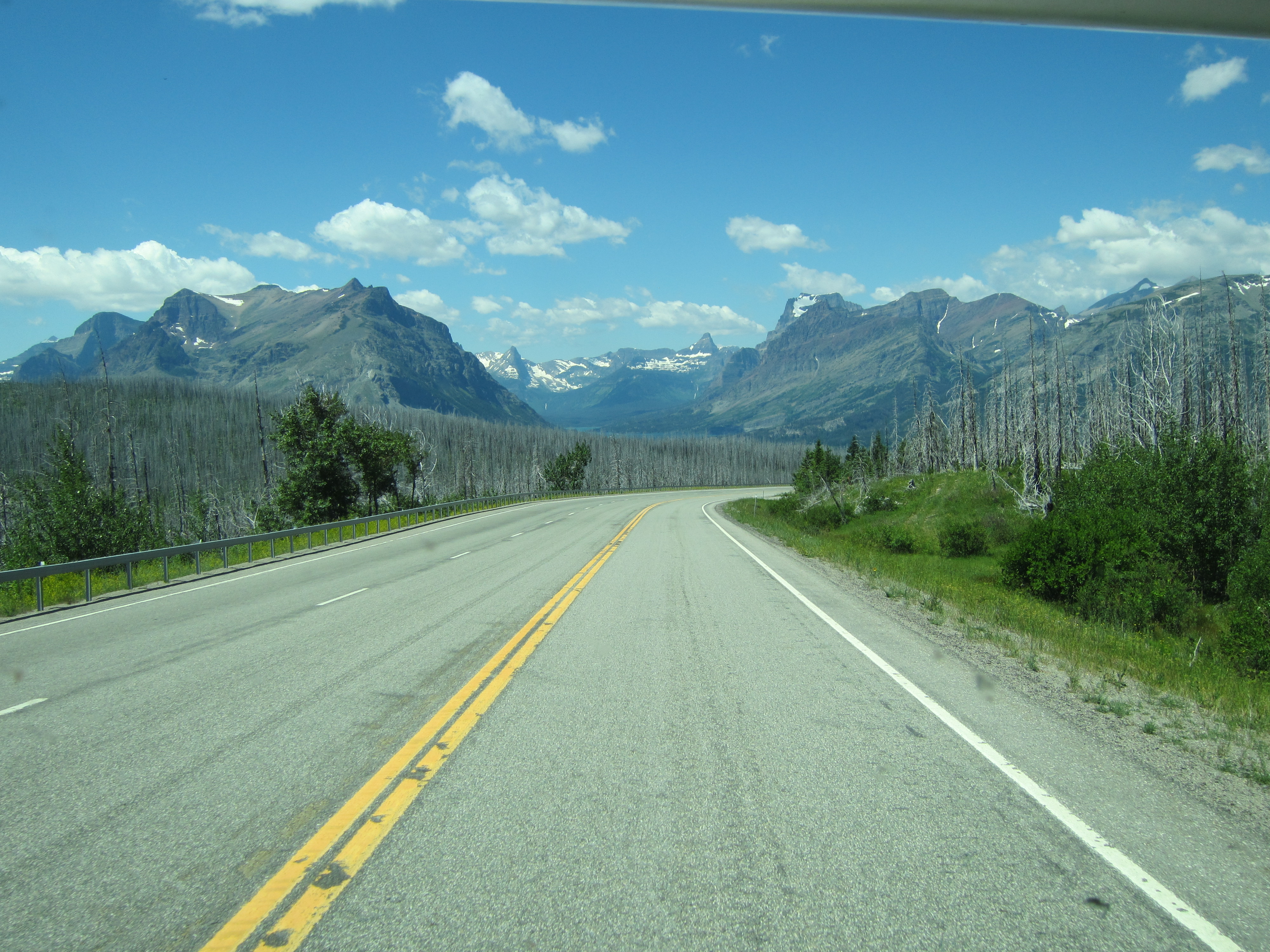
A detour around more of the inevitable road construction takes me through the countryside north of Browning and I meet up with Hwy 89 at the base of the mountains. Turning right we head north to the KOA Campground at St. Mary, MT. The road passes through forests that were decimated by forest fires nearly 10 years ago.


The St. Mary KOA is our home for the next four days. KOA (Kampgrounds of America) is a chain of campgrounds across the US, first started in Billings, of all places. I generally do not stay in KOA’s as in my opinion they tend to be overpriced and crowded, but there are few options available here. As per my pre-conceived notions, this one is also overpriced and crowded. It cost $60 a night for a grass site with only water and electricity but once again the relatively small size of the Lunch Box scored us a good site. At only 24 feet long, we often get the spot at the end of a row which means no neighbor on the door side, a good thing. This KOA is large and sprawls down a gentle hillside towards the St. Mary River near the Going to the Sun entrance to Glacier National Park just a mile to the west. It’s hard to criticize the price too much as they have to make their living in the window between Memorial Day at the end of May and Labor Day at the beginning of September. Whatever the drawbacks, the electricity and water worked, the showers were clean and hot, and you can’t beat the setting. First is the view from my door to the southeast, next is the view northwest.


But Augie the doggie scored best of all, the dog run was huge and certainly had the best view of any place he’s ever done his “business”, bordered by a traditional split rail fence and looking straight up the St. Mary Valley into the heart of Glacier National Park !

Our visit to Glacier National Park resulted in some spectacular pictures, documented in the next three chapters of “The Ramparts of God.”
Next up: Glacier National Park: Many Glacier Valley
Post a Comment