Spring 2013 found Augie and I taking a swing from Oregon back down to southeast Utah/southwest Colorado, back up to Billings, Montana (this was before I moved there in 2014) and then back to Oregon. I had to cut the trip short due to some health issues but still had a great time. Enjoy!
Fairview, OR to Mt. Vernon, OR
The “men” (that would be Augie and I) set out on the Testosterone Trail travelling from Fairview to Boise, Idaho, across central Oregon. We set out travelling east on I-84 to just before Biggs Junction where the road then turned southeast on Hwy 206 to Fossil where we turn south along the John Day River on Hwy 19 until it hits Hwy 26 where we turn east. Thanks again to Oregon taxpayers for maintaining the best state park system yet encountered in the travels of the Lunch Box. We stayed in a trail of jewels on the way to Boise: Deschutes River SRA (at the mouth of the Deschutes where it enters the Columbia), Clyde Holliday SP (just west of John Day and a favorite spot), and Unity Lake SP (east of John Day just across the pass and heading out onto the high plateau). When leaving the edge of the Columbia River at Biggs Junction the road heads south up out of the Columbia River Gorge and into the high plateaus of eastern Oregon. The weather was sunny but breezy the first couple of days, giving great views of Eastern Oregon’s newest cash crop – wind turbines! This view looking northeast is between Biggs Junction and Condon where the turbines rise from fields of dry land wheat.

I think farmers are making more money from the least payments for the turbines than their crops!
In this picture you can see at the bottom of the turbine farm trucks and a combine to give some perspective to the size. After leaving the wheat fields the road follows the John Day River canyon until opening up east of John Day.

Mt. Vernon, OR to Boise, ID
The weather turned damp and COLD with snow on the tops of the mountains bordering the valley (as you can see in this view from Unity Lake looking south down into the John Day River Valley).

 The terrain is much more arid once you cross the Blue Mountains east of John Day, lots of sagebrush and open spaces as we follow HWY 26. HWY 26 and HWY 20 (from Bend) come together at Vale, a small town that leads to Ontario at the border of Oregon and Idaho. Vale was a booming town in the 1890’s as the gateway to central and southeastern Oregon from the east. A prosperous little downtown was built out of native rock as evidenced by the Grand Hotel and Opera House, currently undergoing renovation. Today it’s a bit rundown with a couple of blocks of local businesses hanging on. Otherwise, probably not a memorable stop on the road EXCEPT for today!!!! I try to stop for lunch at a rest stop or city park where Augie and I can stretch our legs while he meets the “call of nature”, and today was no exception. Vale has a nice little park with ball fields, playground, etc., right next to the elementary school. I had an unforeseen brush with the law… We pulled up, went for our walk, and then settled in for lunch (turkey sandwich, couple of chips, apple and a “two-bite Baby Ruth for those who are counting my carbs!). My calm and casual lunch was interrupted by loud knocking on the door. I look out and there is a sheriff’s deputy. Just a tad bit puzzled, I open the door and there he is. It turns out that a little old lady lives across the parking lot and she had called the sheriff (no city police in Vale), reporting a suspicious man lurking at the park, spying on the children. The guy was reasonable and, after I explained what I was doing, he requested a tour of the motorhome (mostly out of curiosity about the Lazy Daze, not looking for evidence of depravity!) He then left, apparently assured that “Chester the Molester” wasn’t lurking in the Vale City Park and America was still safe for the children of Vale! (I saw him wave to the lady, who was kind of hiding behind her curtains keeping tabs on the scene). As I left the parking lot, I, too, waved at her but she pretended that she wasn’t watching. Just a little lunch excitement! After our brush with the law, we continued east to Boise where the weather continued to be sunny but cold. I had to drag out my electric blanket Tuesday night but at least the sun continued to shine. Boise didn’t seem to be particularly memorable so we are heading out tomorrow, but probably deserves a little more research and a return adventure…
Before I pick up the journey a couple of updates:
- A shameless plug for Costco! As many of you know, Augie the doggie started taking meds for his seizures about six months ago. He nearly died from the first med, so was switched to another. Here’s where comparison shopping REALLY paid off. I stopped in Boise to pick up his new three month supply at the Boise Costco. Here’s why: the cost of a three month supply at Walgreens is $718, at PPS mail order $339, and at Costco $63 (none of those numbers is a typo!). The $55 a year for Costco is a bargain…
- Format adjustment. Several people have let me know that they are trying to follow me along on a map so I will be adding a general description of the route to the heading. Thanks again for the feedback/questions.
Here we go…
Boise, ID to Brigham City, UT (I-84 to Mountain Home, US 26 to Idaho Falls, I-15 to Pocatello, US 91 to Brigham City)
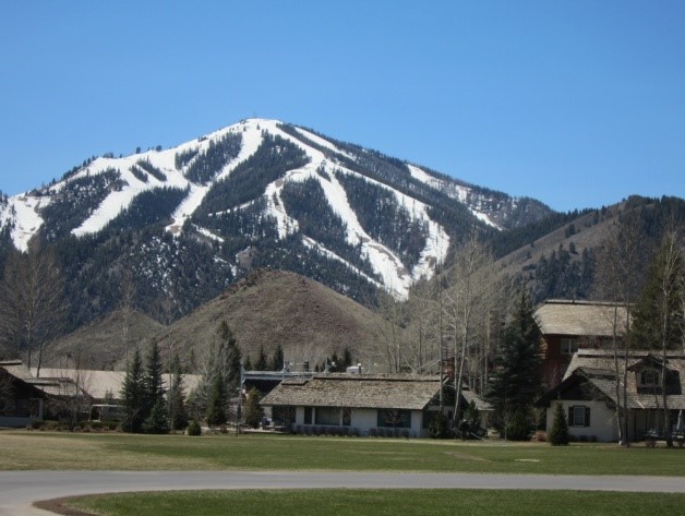
The plan on leaving Boise is to head to the Salt Lake City area, but those of you who have travelled this route know that taking I-84 from Boise to Salt Lake City is a deadly bore. Imagine a bow pointed down. The Snake River essentially travels the path of the bow across the flat plains of southern Idaho, entering on the upper right out of Jackson Hole Wyoming and curving around to leave Idaho northwest of Boise. The ride is all interstate and goes on forever… So remembering my vow to try and stay off the interstate, I take the Goodale Cutoff route, which parallels HWY 26, leaving I-84 at Mountain Home southeast of Boise and cutting across the bow to Blackfoot. This has the added benefit of providing an opportunity for a side trip to Sun Valley. Goodale was a guide who in 1862 led the largest wagon train ever to travel a section of the Oregon Trail. In an effort to avoid hostile Indians along the Snake River, over 330 wagons and 1000+ people gathered at Fort Hall in the east and took the cutoff, lead by Goodale. The effort was so successful (despite hostile traveling conditions) that thereafter the route became more popular than the old route which followed the river. The road hugs the foothills of the Sawtooth Mountains as it crosses Idaho and roughly in the middle HWY 75 heads directly north to Ketchum, Idaho and the resort of Sun Valley. I hadn’t been this way in over 20 years and was surprised at how little it had changed. Ketchum is a small town and Main Street (on the left below) is lined with restored restaurants and shops. The actual Sun Valley Resort (the right below) is about a mile off of Main Street and it’s those blocks where the money shops are located, not on Main Street. VERY tasteful modern buildings with quiet, understated architecture that shrieks of money line the road for a couple of blocks just prior to the resort. Not a Motel 6 to be seen…


After a quick U-turn, we head back south to the intersection with US 26 and turn east, picking up Goodale’s Cutoff. Don’t be mislead – the background of the Ketchum pictures is beautiful mountains, but just 30 miles to the south we are back out on the desolate plains. Shortly we enter terrain that the early pioneers labeled as “Hell”. Thousands of years ago a crack in the earth opened and lava poured out, covering hundreds of miles of south central Idaho. The Craters of the Moon National Monument protects the core of the area.

 Note in the background the foothills of the Sawtooth Mountains stand in stark contrast to the lava flows. There’s essentially no water source along this part of the route so it must have been really rough travelling in a wagon! Stopping for the night in Arco the weather was vintage high desert – reasonably pleasant during the day (though cool) and then quickly turning freezing at night (the low was 22 degrees!) Between the little furnace and my much prized electric blanket we made it through the night but I must say that Augie’s morning “wake-up” jaunt in search of the perfect sage brush to pee on was quick… Then we were off on the last stage of the cutoff to Pocatello. Suddenly lots of government signs warning about security, staying on the highway, etc., start to pop up. Here, in the middle of absolutely nowhere the national government in 1949 established the “National Reactor Testing Station” and in continues to serve as a center for secret government research into nuclear energy (or so they say!) As you drive along you can see complexes of buildings scattered in the distance, along with an airfield that must get enough traffic to warrant a rather significant air control tower. I didn’t stop to take pictures since I have already had my brush with the law this trip! I cross the Snake River at Blackfoot and turn south on a combination of I-15 and Hwy 91 to Pocatello. A reasonably good sized city (50,000+), all of the chain stores and restaurants, etc., are along the freeway. As is my want, I take the old highway through town to check it out. Strung out along a broad canyon it was just store after store, somewhat deteriorating as I got to the older part of town. Then I noticed a taller, older building a couple blocks to the right. It turns out that in Pocatello we had to go “off-off” the beaten track. Taking a right under the train tracks we came upon downtown Pocatello. Full of historic buildings I stumbled on the chance to satisfy one of my own little fetishes! As I travel I like to check out the local high schools, just to see what they are like. Much to my surprise, one block off of Main Street in downtown stands the three block complex that is Pocatello High School. I love this kind of building – built during a time when high schools were seen as temples of learning (i.e. Gresham High), not the local supermarket (i.e. Sam Barlow High), and the architecture reflects that. Indulge me…


Leaving Pocatello I head off on US HWY 91 into the Bear Mountains. The Salt Lake City metroplex spreads out along I-15 on the “Wasatch Front” between the Wasatch Mountains and the Great Salt Lake. But the Wasatch Mountains contain a number of valleys and Logan, Utah, is located in one of those valleys. From Logan to Brigham City is only about 20 miles but you go up and over the mountains to get to Brigham City (which is north of Salt Lake). Touring Utah is all about Mormons and there are two things which always catch my eye: the historic temples and the width of the streets. Every old town has an amazing historic temple, usually built sometime between 1865 and 1880, often paired with a newer, larger more modern temple. Both Logan and Brigham City are examples of this. Here are two temples in Logan. The smaller one on Main Street (started in 1863) was replaced by the larger temple, completed in 1884 on a bluff overlooking the valley. You can see it for miles.

 Brigham City is much smaller than Logan but has a newer temple. The original temple on the left is right across Main Street from the newer temple on the right. I don’t know if Friday May 3 is some kind of special day in the Mormon faith, but I was taking these pictures right around noon and there were FIVE weddings in progress. Brides and photographers everywhere…


The other distinguishing feature of these old Mormon towns is the width of the main streets. Even in Brigham City, again, a small town, Main Street is five traffic lanes wide (two lanes in each direction plus a left turn lane) plus parking on each side. The reason for this is that Brigham Young originally decided that main streets in Mormon settlements had to be wide enough for a team of oxen to turn around and this guideline was copied throughout Utah.
As you can see, the weather remains pleasant, low 70’s during the day and cool nights, but tomorrow we head southeast to the desert.
Moab, here we come!
Post a Comment