New Orleans, LA to Natchitoches, LA (Hwy 90 to New Iberia, I-49 to Natchitoches)
While the French Creole culture of New Orleans rose from early colonists from France, the French influence in southwestern Louisiana actually came from a very different place, eastern Canada. Acadia was a colony of New France in northeastern North America that included parts of eastern Quebec, the Maritime Provinces of Canada and the current state of Maine in the United States. England conquered it in 1710 and for the next 50 years the French (known as Acadians) waged a guerilla war against the British. The Treaty of Paris in 1763 ended the “French and Indian War” and its terms allowed 18 months for Acadians to leave the area. This forced deportation of the culture resulted in families being divided and scattered along the Mississippi River frontier with the bulk of Acadians being welcomed by the Spanish in Louisiana and settled in the swamps and bayous of southwestern Louisiana. The term now applied to them, Cajuns, allegedly did not come into common use until the late 1800’s as a slang term mimicking “Injuns” as a term for Indians with the “Ca” a reference to Canada. Today the southwestern bayou area proudly reveres its past and Acadia, or some similar term, is applied everywhere. My base for exploration is the town of New Iberia with side trips to Avery Island and the city of Lafayette.
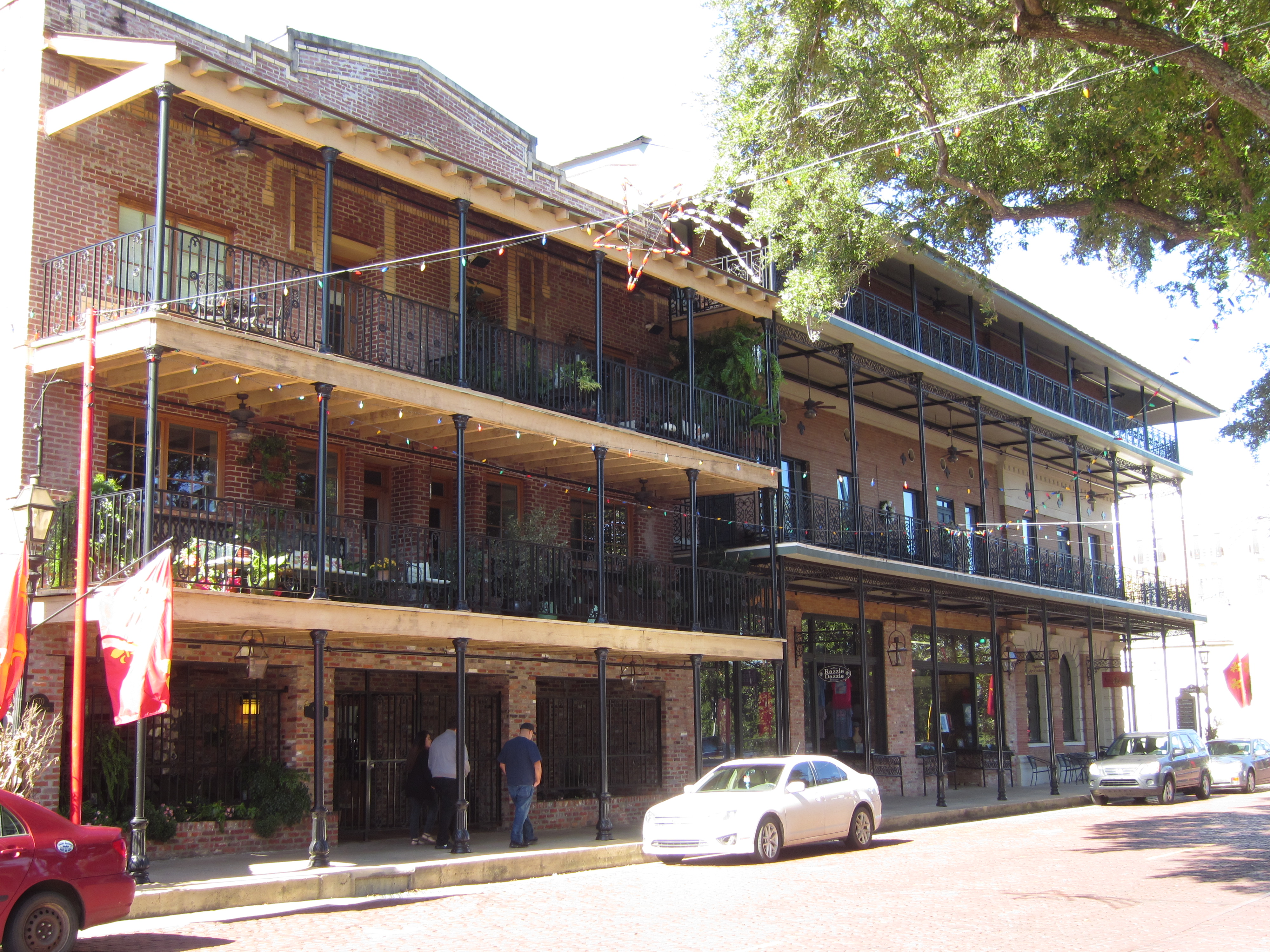
New Iberia
 New Iberia sits on the western bank of Bayou Teche, at one time the main channel of the Mississippi River (historically the river has changed its’ main channel many times, ranging over a wide area of southern Louisiana.) Before the arrival of the railroad, Bayou Teche was a major shipping channel for goods moving south to the Gulf of Mexico. Around 30,000 people live in New Iberia today with the main commercial area west of the old town, which runs along the bayou. The area was first settled by the Spanish in 1779 but the actual town wasn’t incorporated until 1839. Most of the small center area was destroyed by fire in 1899 so the business district mostly dates from then. A plus for me is the relationship that New Iberia has with author James Lee Burke, who has written more than 20 crime novels set around New Iberia featuring Cajun detective Dave Robicheaux (many of which I have read). It was kind of cool to walk around and see locations referenced in his novels!


Anchoring the southern end of the business district is the 1903 Post Office and Shadows-on-the-Teche, an antebellum mansion dating from 1831.

 Past the Post Office Building homes dating from the 1890’s line both sides of the street, many of them bed and breakfast inns.


 Once settled in to the RV Park we head off on our first “field trip” to Avery Island, home of the one and only Tabasco Sauce.
Avery Island
My first surprise was to find that I wasted money on my new luminescent chartreuse Speedo (just kidding!) because there are no beaches on Avery Island. Instead of a stereotypical island surrounded by the balmy Gulf of Mexico, Avery Island is a tree-covered salt dome that rises slightly from the surround sea of undulating reeds and murky water.

The natives operated salt works (boiling the salty spring water to extract salt) prior to the arrival of the Europeans but John Craig Marsh bought the island and began to grow sugar cane. During the Civil War an actual salt mine was developed that became a major producer for the Confederacy until destroyed by Union forces in 1863. In 1868 Edmund McIlhenny founded the McIlhenny Company and began producing Tabasco Sauce from peppers grown on the island, the first from plants which he brought from Central America in 1865. Today only 30 acres of peppers are grown on the island, the rest come from pepper plantations in Central and South America. The same recipe and basic process is used today and all of the Tabasco Sauce sold around the world is produced at this one factory on Avery Island. The complex consists of three buildings: the main factory, a factory store, and a restaurant named 1868.


 An interesting fact is that once the peppers are crushed they are aged in used oak barrels that come from the Jack Daniels distillery in Tennessee (which by law can only use a barrel once).

The factory is not large and on the day that I toured the batch was being bottled for sale in Russia (check out the sign in the picture on the right).


The weather was a bit threatening so we headed back to the RV Park for the rest of the day to wait out thunderstorms. The other side trip was up Hwy 90 in Lafayette to the LARC Acadian Village.
LARC Acadian Village
The Acadian Village was one of the reasons that I decided to come this way. Highly recommended by friend John, the Acadian Village recreates life in Acadia prior to the Civil War. After emigrating from Acadia, the Acadians settled in the swamps and bayous that no one else wanted and like the first wave of many emigrant groups, did the jobs that others did not want to do. They were isolated by their culture and language and did not really begin to assimilate until after the Civil War, when they were no longer unique in their poverty. LARC (Lafayette Association for Retarded Citizens) is a 60 year old organization that supports services for the mentally disabled. In 1976 the board decided to create the Acadian Village as a fundraiser for the organization and so recreated a village, combining restorations of original structures with re-creations. Unfortunately the day I went the complex was essentially closed because they are in the process of creating a massive Christmas light display (which is the major fundraiser for the year and draws thousands). I groveled and so they let me in to wander around the grounds but I was unable to get into any of the buildings. So, if nothing else, this will help you get into the holiday spirit!


It was interesting and I’m sure that the detail in the interiors would have brought the story of the Acadians to life. Oh well… A huge storm (complete with tornado warnings) sat me down again in the RV park and I actually got stranded for a while as the exit road flooded. It was foggy the next morning when we headed north on I-48 to the oldest town in Louisiana, Natchitoches. The landscape changes north of Lafayette and we enter Louisiana hill country.
Natchitoches
The first hurdle in visiting Natchitoches is learning how to pronounce the name without looking like a fool (it’s Nack-i-tish.) Natchitoches was founded by the French in 1714 on the boundary between the French-held territories to the east and the Spanish territories to the west. It originally sat on the banks of the Red River, which provided access to the Mississippi for trade from the west. However in the 1830’s the Red River gradually began to shift to the east and the old channel eventually became cut-off from the main flow and is now a 32 mile long lake called Cane River Lake. Loss of access to the river began a slow decline in the economy of the Natchitoches area although Creole plantations south along the river continued to thrive. Today Natchitoches is a center for tourism as the town stretches along Cane River with parks on the east of Front Street and beautifully restored commercial buildings housing shops, restaurants and bars to the west.


 A block west of Front Street sits the parish courthouse (1895) and the 1857 Immaculate Conception Catholic Church.

 South and southwest of Front Street are charming neighborhoods full of bed and breakfast inns, most dating from after the Civil War, when the city experienced substantial damage.


 Stretching along both sides of Cane River Lake for about 20 miles south of Natchitoches is the Cane River Creole National Heritage Area. Cotton is still grown in the area and fields are ready for harvest.

“Creole” is a term that came into use in colonial times to label things that were created in the New World derived from Old World stock and could apply to people, architecture or livestock. In terms of people, Creole referred to people born in Louisiana during the French and Spanish periods, regardless of race. Several Creole families settled along the river south of Natchitoches and established plantations which originally grew indigo (for cloth dyes) and tobacco but the invention of the cotton gin in 1793 lead to the spread of cotton along the river. The area’s prosperity rose and fell with the fortunes of cotton. After the Civil War several of the plantations south of Natchitoches became virtually self-sufficient and operated until the 1960’s, preserving much of a way of life not as a museum but as part of the organic evolution of a lifestyle. Two plantations along the Cane River south of Natchitoches, Oakland and Magnolia, were in the same families for over two centuries (Oakland-Prud’hommes and Magnolia-LeComptes) and in 1994 became part of Cane River Creole National Park. I visited Oakland.
Oakland Plantation
The founder of Oakland was Jean Pierre Emanuel Prud’homme, who settled in the area along the Cane River in 1785. The plantation was originally called “Bermuda” and the main house, built in 1821, has been slightly renovated over the years as modern utilities came to the plantation. Eight generations of the family lived and worked on this land until it became part of the national park in 1994. The first crops were tobacco and indigo but switched over to cotton in the early 1800s. This is not a restoration but a preservation of a way of life on the plantation as it evolved over time. Unfortunately for me a new roof is being put on the main house and so it was closed. All I could do is walk around the outside. The main house is built on raised brick pillars to keep it off the damp ground at the end of a short alley of oaks that were planted in 1825 leading to the river bank, contributing to the change in name of the plantation from “Bermuda” to “Oakland”.


Here’s a view of the back of the originally house with a later addition on the left. Notice how far they are raised off the ground.

Out buildings line the rear of the house: a pigeonnier (housing pigeons raised for food), a mule barn (originally built as a smokehouse in 1825), and a slave house (located here for display purposes, the slave cabins were originally farther to the west).

Farther east on the left is the 1821 Cook’s Cabin (far enough away from the main house so that fire didn’t pose a danger) and on the right foreground the turkey shed and in the rear, the outhouse. The Cook’s Cabin is actually a “cabin within a cabin” as the smaller actually cooking room is completely surrounded by a screened-in veranda on all four sides. My guess is that it’s an attempt to keep the bugs out (there are a LOT of bugs in Louisiana!)

 The outhouse is a four-seater, including a children’s seat. The difference between current beliefs about privacy and those of the past continue to be interesting, clearly, the process of going to the bathroom was a social occasion in the past!

 Farther back is the tractor shed from the late 1940’s.

In the southwest corner of the complex fronting on the road which follows the riverbank is a general store and post office established by the family in 1868 to serve the area. The store was in operation until 1983.


To the west across a wide space sit the “administrative” buildings and the site of the slave quarters.

Sheltered under the canopy of trees to the left is the Doctor’s House, built in the 1830’s to house a son-in-law who was a doctor and now the park headquarters; the overseer’s house, built in 1861, and the 1821 corn crib and water cistern (the gray cylinder in the picture-it goes 16 feet deep in the ground and held nearly 5,000 gallons of water).


 The key to the longevity of operation of Oakland was the fact that many of the slaves, once freed, remained on the property and worked as sharecroppers and later tenant farmers. Some descendants continue to farm the land today.
Further down the road is a restored antebellum mansion and plantation, Melrose. Again, because this is November and a lull in the tourist season, this house, too, was closed to tours due to maintenance.
Melrose Plantation
Melrose Plantation is significant because it exemplifies the fact that “Creoles of color” were a significant force along the Cane River before the Civil War. Louis Metoyer was the son of a white man and a slave who received the land grant in 1796. The big house was completed in 1833 by his son. One of many multiracial Creole families who became property owners in the area the Metoyers occupied the plantation until 1847 when financial difficulties forced the sale. Another French Creole family, the Hertzog’s, purchased the property and worked it until 1884 when it was sold to Irish immigrant Joseph Henry, who named the property Melrose. The Henry family restored the main house in the early 1900s.

Since it was closed I turned around and went back to the RV Park in Nachitoches to pack up and start heading north. My time in Louisiana has been interesting, but winter’s coming and I need to start heading for home.
Next up: Heading north
Post a Comment